A very different set of tribal groups called Kafirs, once found realm in the inaccessible part of Hindu Kush mountain range. This part some centuries back was named as Kafiristan, the land of non-believers as the neighboring Muslim would call them. Their customs and habits baffled many ethnologists of their origins for a long time. It is believed that these tribes may have settled around 7" or 8" centuries AD, taking refuge in the present valleys. This period is regarded as the spread of Islam into the Indian sub-continent. Their origin seems to be farther into the western region which could be Caucasus Mountains as they share physical features many living habits with them. The greater part of Kafiristan lies into: Afghanistan known as Nuristan — the land of lighted people. They were converted to Islam in 1890s when the Amir of Kabul waged a holy war forcing them into new faith. The part now in Pakistan called Kalash tribal region remains the same with their ancient traditions and pantheon. They are now regarded as an ethnic protectorate under Pakistani law. We see their cultural outlook and traditions still surviving and with the rise of education among many Kalash young generation seems to have got new impetus of survival. A visit into these valleys is an experience and travel into the past living in wooden houses perched on hillocks and looking after their live stacks.
Itineraries
Day 01: Arrive Islamabad – Flt
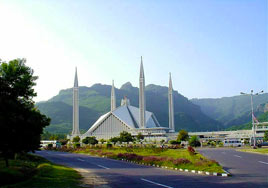 Meeting on arrival assistance and transfer to Hotel Pearl Continental (immediate
rooms)
Meeting on arrival assistance and transfer to Hotel Pearl Continental (immediate
rooms)Afternoon sightseeing tour of Islamabad visit Shakerpanrian see the Institute of Folk Heritage, later drive to the top view point for a general view of capital city, continue down through the main streets looking at various landmarks and buildings. See the Crescent and Star emblem, drive to Foreign Ministry, the Diplomatic enclave, State Bank of Pakistan, the Parliament House, Supreme Court building, President’s Palace and the group of Central Secretariat Buildings Later we shall drive to a model village of Saidpur, had been spared removal to show how Islamabad was 57 years ago. Later continue to Faisal Mosque with its typical Turkish architecture Welcome dinner at mountain view Restaurant.
Overnight
Day 02: Islamabad/Chitral – PK660 – 1115/1225 hrs - Chitral/Bomburet – 30 kms
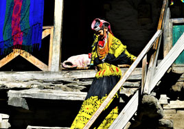 Morning transfer to airport for flight to Chitral on arrival transfer to Chitral Town – we shall take a short walk through the town while in the meantime to prepare the permit for visit of Kalash Valleys Lunch at local TirichMir Hotel restaurant Afterwards short walking tour of Chitral – we shall start with visit of White Mosque, Chitral Fort and later through bazaar Afterwards depart for Bomburet Kalash valley – on arrival transfer to Guest House, Bomburet Dinner and overnight (B,L,D)
Day 03: Bomburet
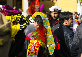 Morning we shall have walking tour of Batrik and Anish village Kalash villages – it will be an interesting opportunity to visit their houses and places of worship to know about Kalash pantheon the mill houses and schools. These are great photo ops. keeping in view the customs and traditions of Kalash people. After lunch at the Guest House we shall proceed on excursion to Rumbur village the second Kalash village later return to your hotel Dinner and overnight(B,L,D)
Kalash Kafirs:
Kalash literally means ‘wearers of black robes’ once associated with a large group of people spread across into Afghanistan. The part in Afghanistan is called Nuristan – the land of lighted people. Nuristan prior to invasion in 1895 by the Emir or King of Afghanistan was known as Kafiristan – land of infidels. At that time Emir of Afghanistan was facing struggle of survival after his progressive reforms were rejected by the clergy and in order to dampen their anger he waged a so called ‘Holy War’ against the Kafirs forcing their conversion to Islam by power and bribe. Infact prior to the invasion of Kafiristan Surgeon Major GS Robertson had visited in 1893.
He wrote interesting intercourse with Kafirs an authoritative account in his book called ‘Kafirs of Hindukush’ writes about their daily life, character and their rituals. His was infact first ever visit of any western traveller into Kafiristan valleys. Kafirs living on the Afghan part were called ‘Red Kafirs’ due to their fair complexion while Kalash the Black Kafirs were considered lower in order and wore black robes and were living in the domains of British India, the part of Chitral State which is now Pakistani territory. Being on British Indian territory they survived the purges of Emir of Afghanistan. But then at the time of ‘Holy War’ interestingly many Red Kafirs fled across into British Indian part to escape prosecution. They are found settled in all the three Kalash valleys at the end of each village and maintain their identity. Though they are also converted to Islam in due course of time as they had kept their relation across the border.
Kalash are subdivided into three valleys, Bomburet, the biggest and wider, Rumbur is the smallest while Birir is more orthodox adhering to Kalash religious belief. The villages in these valleys are mostly built as huge wooden structures artfully clinging to a mountain slope or to cliffs. Nuristani or Shaykh villages at the end of each valley are artfully carved very true to Nuristani architecture where a well know village called Kamdesh is most beautiful and known for wood work.
Kalash pantheon is a low form of idolatry with every village having wooden effigies of various gods put at a prominent village. Their rituals and religious practices and presence of many deities could be early form of Vedic rituals or beliefs. The chief deity and the supreme called ‘Mahadeo’ is placed above a village and its abode is the site of various sacrifices. Groma or place of worship is a large room built of huge logs from pine or cedar trees. This place is mostly used in winter months when outside when outside is cold. Kalash celebrate four annual festivals: Chilimjusht – the spring festival from May 13-16 marks the beginning of spring season and is the time to start tiling the fields. Pul is celebrated in Sep on a full moon day – this marks finishing the work at fields when the produce is gathered. Uchau is celebrated in Oct marks the collection of grapes, apples and shedding of walnuts and collection of corn. This also marks the preparation of wine which is kept in cellars or wooden store houses – box looking. Chaumas – the mid-winter Dec-Jan festival which is indoors and celebrated with final vigour by drinking the already matured wines and sacrificing goats to gods.
Ritual dancing and chants: Every ritual or religious ceremony starts with a sacrifice of goat by the chief priest who utters few chants. On important occasions these sacrifices are followed by ritual dances and chants – well Kalash have lost meanings of their ritual practices but they know these are for enticing a certain deity or god. Sometimes trees are considered as abodes of their deities. They are basically animist believers where as each act of nature is associated with a certain deity. The beliefs are a mixture of Vedic and Avestan practices in their nascent ages. They could have emigrated from the Caucasus region as their burial practices are similar to some early group of nomadic people. They dress the decease in full garb and place it in a wooden coffin which is then placed at an isolated hillside and revisited after certain period of time celebrating the freedom from worldly luxuries to heaven. Normally in the olden times they used to place an effigy signifying the dead person and elaborated with fine wood carving according to the status of the deceased.
Day 04: Bomburet/Chitral – 30 kms
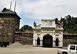 Morning we shall depart for Chitral make short visit of Birir valley – after wards see Guru village proceed to Chitral. On arrival transfer to Hotel Tirichmir Depending on the season there is always probability of Polo Game in the late afternoon Also visit local Museum Overnight (B,L,D)
Chitral Fort:
This edifice of the fame ‘the siege of Chitral’ was a strong fortress built probably in 14th century by the local ruler of Chitral, Nadir Shah. It had served as a stronghold of Mehtars or kings of independent Chitral State. The princely state of Chitral was important to the rising British rule in India since it bordered Hindukush mountain defile separating, from the Imperial Russian territories. The two encroaching powers were busy in the expansion of their domain giving rise to the Great Game yet to be played by the two powers. The British who had consolidated their power base in India by the end of 19th century were equally aware of the Russian threat from the north. In 1890s onwards Hindukush region had become a hot bed of spies and explorers who travelled across difficult defiles mapping and exploring the land which was in oblivion since the invasions of the Mongol armies. The surge of titular rulers resulting in the bifurcation of Mongol empire was natural outcome. Central Asian potentates were large houses with many off springs and whose settlement was carried out by giving huge jagirs or lands throughout Hindukush, Pamir knot and into northern parts of India. The start of the Great Game was the result out of sheer mistrust and fear among the two powers. This gave rise to suspicion prompting race for control of territories and influence among the rulers to rope them into their confidence. These territories were valleys with substantial strategic zones all along the northern borders of the then British India. Chitral was lying in a strategic part, bordering with Pamir and Hindukush terrains. British had made sure to secure these borders by gaining favours of the chieftains of the region.
On the other hand, German and Russian relations with the rise of Prussian Empire in early 19th century was always taken with suspicion by the British. They always had view that Russia with German help might encroach upon the northern territories of the Raj. Chitral was a state of great concern for the British Empire so they had built good relation with the rulers and interacting through a representative called political agent. The other headache for the British was non committal attitudes of the local rulers who were like bargaining pawns and it was necessary to keep a more trusted soul on their side. In 1895 the British political officers faced brunt of the infighting among the ruling family members and the ruler whom the British relied was killed by his brother and the new ruler wanted the British legitimacy. On refusal the whole garrison of British army faced confrontation rather annihilation and had to take refuge into the fort. The army of 400 was besieged for 45 days inside the fort, their rations had exhausted. The British sensing the gravity of the matter prepared two relief forces from Peshawar and one from Gilgit. The Gilgit relief force under Major Kelley reached in time to relieve the besieged army. The power struggle in Chitral started with the death of ruler Amanul Mulk in 1892 and the throne was grabbed by one of his son Afzal ul Mulk, killing many of his family members to consolidate his power base. In the meantime, one the brothers of former ruler Sher Afzal, living in Afghanistan on exile entered Chitral and killed Afzal ul Mulk installing himself but he was removed by Nizam ul Mulk who was the brother of slain Afzal ul Mulk who came under the patronage and support of the British. Nizam was soon murdered by one of his own brother Amir ul Mulk, sparking the intervention of British who removed him and placed with Shuja ul Mulk, the young son of Nizam ul Mulk. While this power struggle was going on British troops under Surgeon Major Robertson had taken refuge in the fort. It is was the relief force under Major Kelley that ended the ordeal after 45 days of siege.
Day 05: Chitral/Mastuj – 112 kms
Morning we shall drive up to Birmoglasht above Chitral town for grand views of Tirichmir Peak(7708m) – this is also reserve for Capra Falconeri (Markhor) Later drive back to your hotel and depart for Mastuj enroute stop at view point of Bunizom peak(6542m) above the village of Buni. We shall have lunch at local house with local cuisine Continue to Mastuj – on arrival transfer to local Guest House
Later walks in the village
Overnight
Later walks in the village
Overnight
Day 06: Mastuj/Miragram/Mastuj
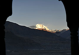 Today we shall make day excursion up in the valley to Miragram village – enroute we shall make stops at beautiful view points with grand mountain scenery of Hindukush region prominent peaks of Tirichmir and Bunizom in the southwest. The valley is called Yarkhun valley which was thoroughfare for the people of upper Pamir and Wakhan region. This valley is an important outlet for people of the mountains whose abode lies in the highest glaciated zone. Make stops to visit the local homes and perhaps shall have a meal will be great occasion to interact with the people of Hindukush.
Return in the late afternoon
Overnight
Day 07: Mastuj/Shandur Pass/Phandar/Yasin/Gupis – 145 kms
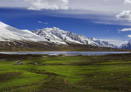 We leave Chitral district drive up to Shandur Pass (3734m) – on top of the valley we shall
see the distance Hindu Raj and then Hindukush drifting more in the north merging closer
to Pamir ranges. We can still see the foot path which was once the route of Chitral relief
force led by Major Kelley in 1895. It was mid March and the pass was full of snow so
much so that it had become difficult for the pony driven cannons to trudge through heavy
snow and even some coolies deserted due extreme weather and fear of being killed by
Chitralis. However Major Kelley’s force made it in time lift the siege of Chitral Fort which
had continued for 45 days.
We leave Chitral district drive up to Shandur Pass (3734m) – on top of the valley we shall
see the distance Hindu Raj and then Hindukush drifting more in the north merging closer
to Pamir ranges. We can still see the foot path which was once the route of Chitral relief
force led by Major Kelley in 1895. It was mid March and the pass was full of snow so
much so that it had become difficult for the pony driven cannons to trudge through heavy
snow and even some coolies deserted due extreme weather and fear of being killed by
Chitralis. However Major Kelley’s force made it in time lift the siege of Chitral Fort which
had continued for 45 days.This is also an interesting crossing point from Khowar speaking villages into the Shinaki and Burusashki speakers of Gilgit and surrounding valleys. We shall enter into more greener land with simmering lakes and rivers. We shall make a short rest at Phandar Lake overlooking the beautiful valley for Lunch. As we descent into more populated parts of the valley. The rivers are teeming with trout brown and rainbow species. As we head more deeper into the valley we keep seeing the change of views.
On arrival at Gupis transfer to local Guest House.
Later we shall leave for Yasin valley following the river passing through various villages we shall arrive at Tawoos village with beautiful views of Hinudraj Peaks
later return to Gupis.
Overnight
Day 08: Gupis/Gilgit/Karimabad – 220 kms
Morning depart for Gilgit we shall enrotue visit Bubur village – once known for its Zoroastrian people and special grape made nut bars – later continue to visit Sher Qila once main village of Punial valley. We shall continue to Gilgit – visit Gilgit bazaar the old hanging bridge, Kargah 8th century rock carved Buddha.
After Lunch we shall proceed to Hunza valley – enroute stop near Rakaposhi Peak view (7788m) on arrival at Karimabad, transfer to Serena Inn.
Overnight. (B,L,D)
After Lunch we shall proceed to Hunza valley – enroute stop near Rakaposhi Peak view (7788m) on arrival at Karimabad, transfer to Serena Inn.
Overnight. (B,L,D)
Day 09: Karimabad Hunza Valley
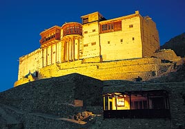 We shall spend a leisurely day walking upto Baltit village and Baltit Fort – the houses in Baltit are reminiscent of old village made of mud and stones and the old mill house is still there though not so much in use as it used to be but still working. It is a great sight in summer months to see ladies bringing their produce at the mill house, gossiping and laughing. Also under the walnut trees we may see elders sitting around talking about daily life. Then slow walk up to Baltit Fort once home to former Mirs or rulers of Hunza.
Afterwards we shall drive to Altit village and Fort. Altit Fort constructed on rock precipice overlooking the river below and perhaps the caravan road which once carried goods from Yarkand to Leh to Kashmir. This was acting as a look out post for raiding the caravans as was the rule of the day until 1869. We shall walk through the village and later drive up to Duikar for panoramic views and late afternoon tea. Later return to Karimabad overnight (B,L,D)
Baltit Fort:
At first sight it looks like a Ladakhi monastery, was constructed by the people of Baltitstan(little Ladakh) who carried their old style. Infact in 15th century one of the Mir of Hunza, Aysho the second married Moghalote princess from Baltistan. She carried a large number of servants as part of dowry customary in ruling families. This may be the reason of its construction as Balti constructors influenced their style typical of Ladakhi architecture. Hence the name has association with Baltistan as Baltit Fort. The fortress is constructed on a prominent point and the nearby glacial waters, the only water supply to the whole village below. A lot of timber carried from Nagar valley and indigenous poplar tree was a very true material for such construction, used in raising the big structure with traditional labyrinth layout in three tiers, subdivided into many smaller rooms with divisions of administrative and living quarters of the rulers family and kin. The best inner parts of the fort are in typical Pamiri construction style with Persian decorative motives while rest of the rooms are ordinary Pamiri rooms for relatives, guards, servants and dens for grain storage basically it reflects a Pamiri and Ladakhi construction style.. The rooms are dark from soot of ages whereas cooking and burning of oil lamps was in the interior common to local household. The thick fat of oil lamps and cooking of years has in turn resulted in protective cover from weather and insect effects. Surprisingly Baltit Fort has sustained the severest of earthquakes and land shifting tremors due to glacial movements. These stable techniques of construction were amazing from the olden days and could absorb the shocks. The fortress was abandoned in 1945 as residence. With the passage of time this structure of 16th century had developed fatiguing problem in its foundations and many parts crumbled due lack of traditional protective measures. There was also lack of interest in the upkeep of the former ruling family. After the death of the last celebrated ruler of Hunza, Mir Jamal Khan, it fell into disuse and neglect. He had spent his childhood in this fortress and often visited the place and even just before his death he did visit as it reminded him of his upbringing there.
After years of neglect and activation of the Agha Khan Trust for Heritage, Baltit Fort and Altit Fort, restoration was undertaken on priority to save this masterpiece of Hunza heritage. The restoration was completed in 1996 undertaken by Royal Geographical Society and Agha Khan Trust for Heritage. Now it runs as museum with regular care under the trust. It is also a candidate for the World Heritage Site Baltit Fort offers a grand view of the valley, its summer canopy on the terrace was scene of Darbars in the open air where every subject of his state had the access and redressal of problems being faced. The biggest problem faced by the population was scarcity of agricultural land and water way for feeding the fields. It offer awe inspiring views of surrounding Rakaposhi Peak(7788m), Golden peak, Ultar peak(7388m) and many smaller above 6000m.
Hunzakuts or people of Hunza:
The people of Hunza is a stock of a racial group which may have settled into Hunza valley from the Pamir where major tribes, once emigrated out of the Caucasus. Their close affinity and physical appearance is more closer to Pamiri people. The ruling and upper class is of Turco-Iranian. There is also strains of Dard who are another Indo-Aryan stock settled here over centuries of migrations. Ethnically they are called Burosho group of people and are Burushaski speakers a language that has baffled many linguists and it is still an isolate language. There is more probability that this language might have relatives in some Caucasian valleys.
Hunzakuts are well stocked people, sturdy and agile as the daily workouts in the fields and climbing rocks is normal mode of life. Animal husbandry which was one of the prime profession from the start as in the olden days every household used to have several animal comprising cows, goats and sheep however the changing times many have resorted to more modern commercial professions. There are people who still profess agriculture which is a laborious job owing to scarcity of land giving rise step agriculture or terracing very true of all mountain communities but this profession is also effected by the changing times and this profession is left to mostly those who prefer to till the land. In the past due to poor farming produce was always scarce. But after the construction of Karakorum Highway(KKH) has not only drastically changed normal way of life but has also helped in healthy farming and other related professions. Hunzakuts are great climbers from their childhood and they would perch up the precarious hills to construct a water channelsliterally sticking with the hillside to bring water from a glacial source down to the fields. Great discipline is observed in water distribution that none of the field is left without being watered. This custom continues till today though the younger generation is more prone to jobs outside their villages to main cities of the country.
Day 10: Karimabad/Gilgit – 110 kms
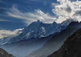 Morning departure for Gilgit – we shall make several short stops near the best views of Rakaposhi peak and villages down below On arrival transfer to Hotel Gilgit Serena After lunch we shall make short tour of Gilgit – see the old bridge of Gilgit and walk along the old street, later visit the commissioner/s house used to be the British Political Agent’s residence and office, afterwards we shall make a short stop at the British cemetery – see the grave of Hayward, the British explorer who was assassinated on the high pass of Darkot. In the late afternoon we might see a polo match as is customary, this game is often played on daily basis among local teams
overnight British Explorers: At the height of mid 19th century the expansion in Central Asia, Turkestan, both British and Russian Empire started crawling out of their newly acquired territories which had become smaller governing set ups of the princely rulers of the Greater Khanates. They maintained similar titles of their predecessors and ruled on a loosed and militarily weak form of governance. Both the British and Russians had realised this weaknesses through their informers who were sent as explorers of the newer territories. This frenzy of reaching Pamir, Hindukush, Tibet and Mongolia had become top priorities resulting in the expansionist policies. These explorers not only acted as informers but were source of great multilateral research informing the local conditions to the outer world since the Silk Road days. We must commend these explorers come what origins they had but how they braved local hostile conditions risking their lives at the cost of being killed or perished in the inhospitable weathers and defiles they had to pass through. This is a long list of explorers whom the history will honour for their work. Some may not be recognised but the present governments of the region terming them as thieves or spies etc. but once looking at their works in their respective territories one cannot deny the great works of merit they deserve. Peter the Great sent a team of explorers eastwards in the Siberian forests to Altai the home of Scythians for searching the mines which had provided these wandering tribes, gold and iron for centuries. Their daggers had even reached Roman armies and they traded in gold as well. These exploratory teams bumped into heaps of mounds turned out to be tombs of the princely families which we term as kurgans. The later 19th to early 20th century we see an era of expansionist pursuits and travel of explorers in northern parts of India, Central Asia including Turkestan the present Sinkiang province of China. Capt Younghusband, Sven Hedin, Count Otani, Albert von Lecoq, Connally and Stoddart, Hayward are of many who ventured, wrote and some perished but the history will remember them.
Day 11: Gilgit/Skardu/Shiger – 232 kms
Morning we shall depart for the most densely mountainous region of Skardu valley also known as little Ladakh. There will be short stops enroute as we follow river Indus through its narrowest gorge seeing the frenzy of glacial waters.
On arrival in Skardu after a brief stop for Lunch at local restaurant we shall proceed further to the gateway to the mountain throne, Shiger. After re-crossing the Indus river we had to Shiger through desert stony drive on arrival transfer to Shiger Serena Residence – beautifully conversion from old traditional fortress the home of former rajas of Shiger valley. Time permitting we can have a short stroll around the residence overnight. (B,L,D)
On arrival in Skardu after a brief stop for Lunch at local restaurant we shall proceed further to the gateway to the mountain throne, Shiger. After re-crossing the Indus river we had to Shiger through desert stony drive on arrival transfer to Shiger Serena Residence – beautifully conversion from old traditional fortress the home of former rajas of Shiger valley. Time permitting we can have a short stroll around the residence overnight. (B,L,D)
Day 12: Shiger/Khaplu – 132 kms
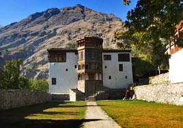 Shiger/Khaplu – 132 kms
Wes shall spend the morning visiting Khaplu village see the old mosque, Imambarga and meet local folks in the village. It will interesting to see the wooden structures in typical Ladakhi architecture though Muslim but still retaining Buddhist symbolism in construction designs. After lunch at our residence depart for Khaplu, retracing to main road and continue through desolate scenery. We shall leave the vast expanse of Indus which flows down from Kharmang valley over Kargil. Now continue along Shyok River as proceed closer we shall see numerous Balti village. On arrival transfer to Serena Khaplu Residence – yet another beautifully converted residence of the former rulers this is a beautiful place with nice views all around.
Shiger/Khaplu – 132 kms
Wes shall spend the morning visiting Khaplu village see the old mosque, Imambarga and meet local folks in the village. It will interesting to see the wooden structures in typical Ladakhi architecture though Muslim but still retaining Buddhist symbolism in construction designs. After lunch at our residence depart for Khaplu, retracing to main road and continue through desolate scenery. We shall leave the vast expanse of Indus which flows down from Kharmang valley over Kargil. Now continue along Shyok River as proceed closer we shall see numerous Balti village. On arrival transfer to Serena Khaplu Residence – yet another beautifully converted residence of the former rulers this is a beautiful place with nice views all around.We shall make short walks to the grand mosque called Chaqchan Mosque is finest example of Ladakhi/Tibetan architecture with admixture of Persian designing. The mosque built in 14th century when Islam spread in this region by Mir Sayid Ali Hamadani who led the Sufi order of Kibrawiyya later passed by his disciple to Sufi Saint Syed Mir Muhammad Nurbaksh who came from Kashmir to Baltistan. His order projects pursuit of middle order between Sunni and Shia thoughts.
Overnight
Day 13: Khaplu/Hushe/Khaplu
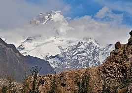 In the morning we shall embark upon in the neighbourhood of mount K-2 however we are too close view the great mountain but we can see Masherbrum peak (7821m). This will be very interesting road drive with mighty Karakorum range around us have some striking moments once we reach Machlu village with its wooden mosques and houses. We shall continue till Hushe village at the end of the road drive – this is a popular trekking point over Gandoghoro-la to Baltoro Glacier to Concordia further to the base of mount K-2
We shall spend time walk into the village meet the local folks and see their way of life. After Lunch at Little Karim’s Guest House we shall return to Khaplu Later walks in Khaplu to meet the local folks see the other mosques.
Overnight
Day 14: Khaplu/Skardu – 118 kms
Morning drive back to Skardu – on arrival we shall transfer to Hotel One Lunch at hotel and then leave for Sadpara Lake – our first stop will be at the Manthal village near Sadpara to walk up to a huge boulder with craved image of Buddhas – Adi Buddha surrounded of other images of Buddha – Adi Buddha is carved in bhumispara Mudra (touching the earth) surrounded by other smaller dates from 8th AD. The period from 8th to 9th century AD we hear of Tibetan invasions into these parts extending upto Gilgit. After visiting the rock we shall drive further down to Sadpara to see the lake later return to Skardu – visit the local bazaar overnight (B,L,D)
Day 15: Skardu/Islamabad – Flt
Morning transfer to airport for flight to Islamabad – this is a spectacular flight through and over the mountains with a sea of highest concentration high mountains on arrival transfer to Hotel Pearl Continental free at leisure.
Overnight (B,L,D)
Overnight (B,L,D)
Day 16: Islamabad
Morning excursion to Taxila – we shall visit the site dating back from 5th BC to 5th AD We shall visit the site of Dharmarajika the Oldest Stupa dates from 1st AD, later drive to the second city of Taxila – Sirkap 1st BC to 1st AD – see city plan, the shrine of Double Headed Eagle, the Acropolis Hill and court of smaller stupa shrine. Afterwards proceed to Jaulian Buddhist monastery perched on a hill – see the best preserved stupa court and monastery quarters. Afterward we shall drive to Mohra Moradu, the royal monastery has a beautiful stupa in a cell still surviving since 5th AD.
Lunch at local restaurant
We shall then visit the beautifully laid out Archaeological Museum of Taxila exhibiting artefacts from 1st BC to 5th AD
Later return to Islamabad
Farewell Dinner at local restaurant
Overnight (B,L,D)
Lunch at local restaurant
We shall then visit the beautifully laid out Archaeological Museum of Taxila exhibiting artefacts from 1st BC to 5th AD
Later return to Islamabad
Farewell Dinner at local restaurant
Overnight (B,L,D)
Day 17: Islamabad/Depart – Flt
Transfer to airport for your destination flight – assistance on departure
Gallery
View the embedded image gallery online at:
https://ahutravelntourism.com/index.php?option=com_content&view=article&id=240&Itemid=674#sigProId32fdb26ca1
https://ahutravelntourism.com/index.php?option=com_content&view=article&id=240&Itemid=674#sigProId32fdb26ca1


